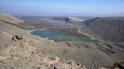
BPX 3-Day: Powderhorn Lakes from Powderhorn Lakes TH
The relatively unknown Powderhorn Wilderness, north of Lake City, is said to have the largest continuous extent of alpine tundra in the lower 48 states, with a mix of lakes and expansive views. Spend time at the lakes and hiking on the high mesas above tree line where there are great views of the San Juan range. This out-and-back trip is moderately difficult with 10 miles and 1,700 vertical feet.
Suggested Backpacking Section (BPX) itinerary for 3-day trip to be used for CMC trips led by BPX leaders for BPX members:
Day 1. Hike 5 miles on the Powderhorn Lakes Trail to the Upper Powderhorn Lake and establish camp in the basin (5 miles/+1200’, -500’).
Day 2. On an optional day hike, climb steeply from the lake above tree line to the top of the Calf Creek Plateau. Day hike 1.5 miles across the plateau to beautiful Devil's Lake set like a jewel on the sweeping high mesa. If the weather is good, also climb to the high point on the Cannibal Plateau, named for the Alferd Packer exploits, and then hike back to camp at Powderhorn Lake.
Day 3. Hike back to the trailhead (5 miles/+500’,-1200).
Driving Directions: From Gunnison drive 9 miles west on Hwy. 50 to Hwy.149 and turn left. Follow Hwy. 149 south for 20 miles. Turn left on Indian Creek Road (County Rd. 58) and follow the rough 2-wheel drive road for 10 miles. The trailhead sign and parking area are at the end of the road.
General Requirements: The campsite near the lake will be at treeline but the plateaus are wide open, but there are few clear trails, so wayfinding will be a team project. Care will need to be taken when hiking on the high plateaus where there is little shelter from storms. It is possible to camp at the trailhead.
- Suitable Activities: Backpacking
- Seasons: July, August, September
- Weather: View weather forecast
- Difficulty: Moderate
- Length: 10.0 mi
- Elevation Gain: 1,050 ft
- 11,870 ft
-
Land Manager:
U.S. Forest Service
Powderhorn Wilderness Area, Gunnison Ranger District (GMUG)
- Parking Permit Required: USFS Permits & Passes
- Recommended Party Size: 12
- Maximum Party Size: 15
- Maximum Route/Place Capacity: 15
- Trails Illustrated 139
There are no resources for this route/place. Log in and send us updates, images, or resources.
