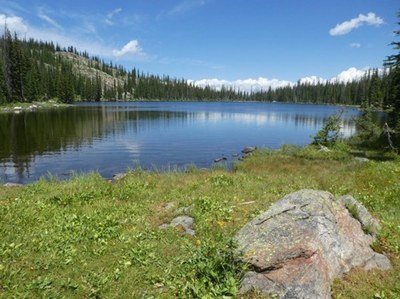
BPX 3-Day: Fishhook Lake from Rabbit Ears Pass TH
Enjoy the wildflowers and moose on this easy hike to Fishhook Lake (or slightly farther Lost Lake) starting from scenic Rabbit Ears Pass/Dumont Lake area with the option to climb Rabbit Ears Peak on the last day. This is a 3-day Out and Back with 9.8 miles and 1300ft elevation gain.
Suggested Backpacking Section (BPX) itinerary for 3-day trip to be used for CMC trips led by BPX leaders for BPX members:
Day 1 – Park near Wyoming TH and take the Wyoming trail 1101 northwest past Dumont Lake. Lots of wildflowers and moose through this area. Continue on 1101 past the Basecamp TH (requires 4WD or at least high clearance vehicle to access) and then another 2 miles to Fishhook Lake. Lost Lake is just another ½ miles with a well-marked turn-off from 1101. Remember Moose are Colorado’s deadliest animals – keep your distance. (4.9 miles, 800 feet up and 400 down).
Day 2 – Explore this beautiful area. Fish, hike, relax
Day 3- Return early on the same path back to cars. Optional add-on is Rabbit Ears Peak – from the same parking area follow FS 4WD road 311 north approximately 1000 feet and then right on FS 4WD road 291 to top of Rabbit Ears Peak. (5.4 miles RT and 1,000 feet elevation gain). 4WD road to Rabbit Ears peak is closed to all vehicles in the early summer season so that is the best time for this portion of the hike.
Driving Directions: From Wooly Mammoth PnR take I-70 to Silverton and then north on highway 9 to Kremmling and then highway 40 north to Muddy Pass and continue west on 40 to turn-off for Rabbit Ears East Pass parking and Dumont Lake. Take that road past the turn-off for campground and stop at the monument – Wyoming TH is just north of the monument.
General Requirements: Hiking conditions are best from mid-June through October. July can be buggy, but the flowers are best then. Maps: National Geographic 117 Clark, Buffalo Pass and 118 Steamboat Springs, Rabbits Ears Pass.
- Suitable Activities: Backpacking
- Seasons: June, July, August, September, October
- Weather: View weather forecast
- Difficulty: Easy
- Length: 9.8 mi
- Elevation Gain: 1,300 ft
- 10,043 ft
-
Land Manager:
U.S. Forest Service
Hahns Peak/Bears Ears Ranger District (RNF)
- Parking Permit Required: USFS Permits & Passes
- Recommended Party Size: 6
- Maximum Party Size: 12
- Maximum Route/Place Capacity: 12
- Trails Illustrated 117
- Trails Illustrated 118
There are no resources for this route/place. Log in and send us updates, images, or resources.
