BPX 3-Day: Elliott Ridge and Gore Range Trail from Elliott Ridge TH
Trip is in north end of Eagles Nest Wilderness and takes Elliott’s Ridge, with optional side excursion to Meridian Peak, and then connecting with the Gore Range trail for camping at nice unnamed lakes. Next day continues Upper Cataract Lake with camping at Eaglesmere Lakes. Final day completes the loop back to trailhead along the Gore Range trail and North Fork Elliott Creek Trail. Loop is 20.5 miles and 4,100 vertical feet.
Suggested Backpacking Section (BPX) itinerary for 3-day trip to be used for CMC trips led by BPX leaders for BPX members:
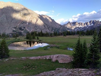
Day 1: From the Elliott Ridge TH take Elliott Ridge Trail 1895 to the SSE. After 5 miles, you need to decide if you want to go to Meridian Peak or not. If not, bear left on Upper Cataract Trail 63, which is very faint at times in this area. To go to Meridian Peak continue to follow the ridge, on or off trail. Meridian Peak offers great views into a rugged part of the Gore Range. Retrace your steps to get back on Upper Cataract Trail 6 and after less than one mile and going down some zigzags, you will see a relatively flat area with a lake to your left (east) with plenty of camping options and water (39.783756°N 106.375°W; see also photo) (6.1 miles, 1,100 feet up – optional excursion to Meridina Peak adds 2.0 miles and 500 feet vertical).
Day 2: Continue down Upper Cataract Lake Trail through gorgeous wildflowers and massive trees. Note: there is a significant climb between Mirror Lake and Upper Cataract Lake, and the latter requires taking a short informal trail to the right. Continue until the intersection of Trail 63 and the Gore Range Trail (Trl 60). Take Trl 60 to the NW. Camp at Eaglesmere Lakes, which have plenty of options. The camping options along Tipperary Lake are more limited for a group; we camped along Cataract Creek, to the left (S) of Trail 60, but options are also limited there for a group. (8.8 miles, 1,500 feet up and 1,700 down).
Day 3: Continue on Trail 60 W and NW. Shortly after leaving the Eagles Nest Wilderness, turn left onto North Fork Elliott Creek Trail 1831.1A (may just be indicated as 1A), then continue on jeep road 1831 to your vehicles. (5.6 miles, 1,500 feet up).
Driving Directions: From I-70 take Exit 205, Silverthorne/Dillon, and travel north on HWY 9 for approximately 27 miles into Grand County. Approximately 2.5 miles past Green Mountain Reservoir turn left onto Spring Creek Road, Grand County Road 10. Follow Spring Creek Road (GCR 10) for 6.1 miles to Doenz Place/Spring Creek TH turn left at intersection. After this intersection the road becomes FR 2773/23. Continue on FR 23 for approximately 1.1 miles until the fork in the road. Take the right fork to stay on FR 23, and travel approximately 2.8 miles to fork left an FS 1834 and another 2.6 miles to Elliot’s Ridge Trailhead. Note that the last 200 yards are very rough, so it may be advisable to park before the trailhead, in the clearing around the intersection with jeep road 1831.1.
General Requirements: To avoid weather trouble or getting up at ungodly hours, you could drive to near the Elliott Ridge TH the afternoon before and camp there (bring water in your vehicle), so that you can get an early start on the exposed terrain. Technically, this makes it a 4-day trip. Another option is to do the backpack in the opposite direction (counter-clockwise, i.e. jeep road 1831 – Trail 60 – Trail 63 – Trail 1886; that would require a 2,500 ft elevation gain on Day 2, unless you camp at Mirror Lake for example).
- Suitable Activities: Backpacking
- Seasons: June, July, August, September
- Weather: View weather forecast
- Difficulty: Moderate
- Length: 20.5 mi
- Elevation Gain: 4,100 ft
- 11,946 ft
-
Land Manager:
U.S. Forest Service
Eagles Nest Wilderness Area, Dillon Ranger District (WRNF)
- Parking Permit Required: USFS Permits & Passes
- Recommended Party Size: 6
- Maximum Party Size: 12
- Maximum Route/Place Capacity: 12
- Trails Illustrated 107
There are no resources for this route/place. Log in and send us updates, images, or resources.
