BPX 3-Day: Deer Lake from Stillwater Reservoir TH
Enjoy the beautiful Flat Tops Wilderness area with this moderate loop backpacking trip to your choice of higher unnamed lakes or the more popular Deer Lake, all locations just at tree line. The difficult trip is 12.6 miles out and back with 1,900 feet elevation gain.
Suggested Backpacking Section (BPX) itinerary for 3-day trip to be used for CMC trips led by BPX leaders for BPX members:
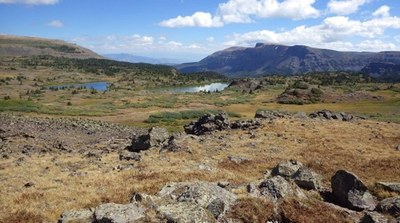
Day 1: From the Stillwater Reservoir TH, hike up the East Fork Trail 1119 along the north shore. Continue along the lake shore on the Bear River Trail 1120. At the top of the mesa, take the Chinese Wall Trail 1803 to the left (due south). At the next intersection, bear left onto the Deer Lake Trail 1802. From the top of the escarpment south of this intersection, you will see two good size lakes about half a mile to your left (39.968008°N 107.16°W; see photo below). Hike off-trail to those lakes and set up camp for 2 nights. (Day 1: 6.3 miles, 1,500 feet up and 400 down).
Another option is to turn right at the top of the escarpment and hike off-trail about 1/2 miles south along the edge of the mesa. This will lead you to a decent size lake draining west into a waterfall running down the escarpment. Views are splendid but this area offers almost no shelter against lightning.
Day 2: Day hike with light pack: Continue south on Deer Lake Trail (Trl 1802). After hiking out of the Deer Lake drainage, some careful route finding will be needed because the trail becomes very faint. This section of the loop is particularly spectacular. At the intersection of Trail 1802 with Trail 1842 (the Island Lakes Trail), you have the option of taking a short stroll to go admire Upper Island Lake: just turn left onto Trail 1842, then very shortly turn right onto Trail 1857 (South Derby Trail) and the lake will be to your right in a couple hundred yards; afterwards, retrace your steps to the intersection of 1802 and 1842. Turn west (uphill) on 1842 to continue the loop clockwise. Hike west on 1842 to climb out of the Island Lakes basin. Pass the junction with 1817 (West Mountain Trail) and stay on 1842 until you reach the junction with 1803, the Chinese Wall Trail; take 1803 straight ahead (north). Follow 1803 north and enjoy expansive tundra views on the western mesas and the Trappers Lake drainage; the trail is faint in places, focus on keeping your heading and look for trail posts. Follow 1803 north until its intersection with 1802, then turn south on 1802 and return to camp. (10.4 miles, 1,900 feet up and 1,900 down).
Day 3: Retrace your Day 1 steps and return to Stillwater reservoir and your vehicles via 1803 north, then 1120, and 1119.
Driving Directions: In Yampa, take Moffat Ave. and CR 7 to the end of FS RD 900 and Stillwater Reservoir. The road is mostly good gravel and takes about 30 minutes. Restrooms available at TH.
General Requirements: Hiking conditions are best from mid-June after major snow has melted, through October. July can be buggy, but the flowers are best then. Most of this hike is above tree line with no protection from lightning.
Suggested camp site along Deer Lake Trail, Flat Tops (we camped between the two lakes on the photo)
- Suitable Activities: Backpacking
- Seasons: July, August, September
- Weather: View weather forecast
- Difficulty: Difficult
- Length: 12.6 mi
- Elevation Gain: 1,900 ft
- 11,518 ft
-
Land Manager:
U.S. Forest Service
Flat Tops Wilderness Area, Yampa Ranger District (RNF)
- Parking Permit Required: USFS Permits & Passes
- Recommended Party Size: 6
- Maximum Party Size: 12
- Maximum Route/Place Capacity: 12
- Trail Illustrated 122
There are no resources for this route/place. Log in and send us updates, images, or resources.
