BPX 3-Day: Crag Crest Trail from Crag Crest West TH
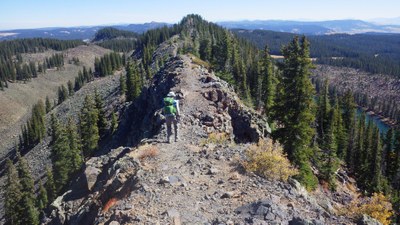
The Crag Crest Trail on Grand Mesa includes a narrow ridge (NOT for the faint hearted!) with dramatic views of the rainbow-colored Book & Roan Cliffs. The second half of this moderate 12-mile loop goes up and down through meadows and forest.
Feel like you are on top of the world while striding along this popular National Recreational Trail that never drops below 10,000 ft on Grand Mesa. Beginning from the West Crag Crest TH, this 12-mile hike takes you over a narrow ridge flanked by steep cliffs, and meandering meadows to the Crest’s high point at 11,189 ft. Along the journey you will experience dense pine and spruce forests, wild flowers, aspen groves, shimmering lakes and a spires and pinnacles overhead. This route has you camping two nights at campgrounds, carrying all gear with you.
Grand Mesa is the world's largest flat top mountain and offers high alpine meadows and incredible wild flowers in summer.
Suggested Backpacking Section (BPX) itinerary for 3-day trip to be used for CMC trips led by BPX leaders for BPX members:
Day 1: Drive to Crag Crest West Trailhead (approx. 4 hrs from Golden). Pit toilets. Stay at Cobbett Lake Campground, $16/night, first come first served. On the lake shore, lots of shade, vault toilets and drinking water ()
Day 2: Hike on Crag-Cobbett Trail #749 to reach the Crag Crest National Recreational Trail #711. Turn right then stay left to hike clockwise around the loop. Continue hiking along the Crag Crest Trail for 5 miles (800 ft ascent and 900ft descent). This section is narrow in places but with dramatic views of the rainbow-colored Book and Roan cliffs, several lakes, the West Elk Mountains, the San Juan Mountains, and the La Sals. Descend to the East TH and camp at the Crag Crest Campground, first come, first served, lightly used. Vault toilets () (7.25 miles/ 1183 elevation)
Day 3: Complete the loop by hiking the lower portion of the loop back to the West Crag Crest TH, 5 miles, 780ft ascent/ 750 descent.
Option to visit the Grand Mesa Visitor Center before driving home. Several campground options near the Visitors Center if you want to stay longer.
Driving Directions:
To Cobbett Lake campground: From Cedaredge, travel north on Highway 65 approximately 15 miles. Just past the Grand Mesa Visitor Center, watch for the campground sign and turnoff road to the right.
Maps:
Comments:
Alternative: Twelve mile day hike, staying both nights at Cobbett Lake campground.
- Suitable Activities: Backpacking
- Seasons: July, August, September
- Weather: View weather forecast
- Difficulty: Moderate
- Length: 12.0 mi
- Elevation Gain: 1,900 ft
- 11,189 ft
-
Land Manager:
U.S. Forest Service
Grand Valley Ranger District (GMUG)
- Parking Permit Required: USFS Permits & Passes
- Recommended Party Size: 12
- Maximum Party Size: 12
- Maximum Route/Place Capacity: 12
There are no resources for this route/place. Log in and send us updates, images, or resources.
