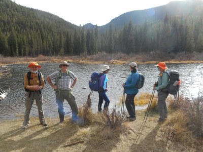
BPX 2-Day: Wigwam Park from Wigwam TH
A moderate 8-mile out-and-back trip from the east end of Wigwam Trail in the Lost Creek Wilderness makes for a good shoulder-season trip, and offers fishing at a series of beaver ponds.
Short backpack to Wigwam Park in the Lost Creek Wilderness for relaxation and fishing at the beaver ponds. This trip makes a good season starter as the east end of Wigwam Trail tends to be snow-free by late spring.
Suggested Backpacking Section (BPX) itinerary for 2-day trip to be used for CMC trips led by BPX leaders for BPX members:
Day 1: Drive to Wigwam Trailhead. Hike west on Wigwam Trail (#609) with a steady gradient, paralleling Wigwam Creek to the Beaver Ponds at 3.5 miles or beyond to the intersection with Rolling Creek Trail (#663) at 4.0 miles. There are several creek crossings. Find a good campsite and overnight. (4.1 miles, +1,600 ft)
Day 2: Pack out to the Wigwam TH via the Wigwam Trail (#609) the next morning and drive back to Denver (4.1 miles, +122 / -1,600 ft).
Overall Route: 8.2 miles, +-1,766 ft.
NOTES:
- More information about Lost Creek Wilderness is available here.
- Wigwam Trail (#609) is reliable all season, making this a good September/October trip, as well.
- Fishing at the Beaver ponds should be good, if small size.
- Driving Directions: From Denver area, drive south on 285 to Pine Valley Rd. Turn left on Pine Valley Rd and continue until road turns into Deckers Rd. Make right onto 550/Redskin Creek Rd where the Colorado Trail crosses Deckers Rd. Continue on 550 to 543/S Buffalo Creek Rd, take 543 to Wellington Lake. Make left onto 560/Stoney Pass Rd, then a right on Fr 545. Road ends at Wigwam Trailhead.
- Suitable Activities: Backpacking
- Seasons: June, July, August, September, October
- Weather: View weather forecast
- Difficulty: Moderate
- Length: 8.2 mi
- Elevation Gain: 1,600 ft
- 9,657 ft
-
Land Manager:
U.S. Forest Service
Lost Creek Wilderness Area, South Platte Ranger District (PSINF)
- Parking Permit Required: USFS Permits & Passes
- Recommended Party Size: 8
- Maximum Party Size: 8
- Maximum Route/Place Capacity: 8
- Trails Illustrated 105
There are no resources for this route/place. Log in and send us updates, images, or resources.
