BPX 2-Day: Crater Lake from Monarch Lake TH
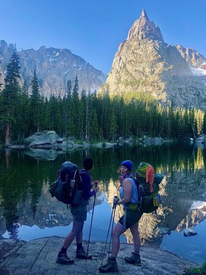
This difficult 14.4 mile trip is a beloved Colorado classic, ending at the photogenic Mirror Lake with Lone Eagle Peak's distinctive profile reflected in the still alpine waters. As one of the most popular destinations in Indian Peaks Wilderness, make sure you have the correct permits and camp only at designated sites around Mirror and Crater Lakes.
Description: Mostly flat for about 4 miles at the start, the trail ascends alongside Buchanan and Cascade Creeks offering gorgeous views of the surrounding wilderness and small waterfalls. The tranquil Mirror and Crater Lakes mark the end, sporting 12 designated campsites and stunning views of Lone Eagle Peak.
Suggested Backpacking Section (BPX) itinerary for 2-day trip to be used for CMC trips led by BPX leaders for BPX members:
Day 1: Hike from the Monarch Lake TH on the Cascade Creek Trail (#1) to Mirror and Crater Lake (7.25 miles, +2,377 / -340 ft.). Camp only at designated sites and avoid the group site, which is reserved as part of the permit process. Other permits allow camping at any open designated site around the lakes (check with Forest Service ahead of time, as these regulations might change).
Day 2: Hike back to Monarch Lake TH (7.25 miles, +340 / -2,377 ft.)
Overall Route: 14.4 miles, +-2,816 ft.
NOTES:
- Always practice Leave No Trace techniques.
- More information about Indian Peaks Wilderness is available here.
- Please view this document with everything you need to know about Indian Peaks Wilderness
- Permits are required for overnight stays in the Indian Peaks Wilderness (IPW) from June 1 to September 15. Additional permit requirements exist for large and organized groups. Car passes are also required for the trailheads in the Recreation Area. The car passes can be obtained at the Forest Service office in Granby or at the self-serve kiosks at the entrance to the Recreation Area.
- Driving Directions: From the Colorado Mountain Club (Golden, CO) to the Monarch Lake TH.
-
General Requirements: Parking Fee at TH
- There was storm damage in 2020 causing downed trees on the trail for the last mile to the lake. The trail has been cleared.
- Suitable Activities: Backpacking
- Seasons: July, August, September
- Weather: View weather forecast
- Difficulty: Challenging
- Length: 14.4 mi
- Elevation Gain: 2,816 ft
- 10,360 ft
-
Land Manager:
U.S. Forest Service
Indian Peaks Wilderness Area, Sulphur Ranger District (ARNF)
- Parking Permit Required: USFS Permits & Passes
- Recommended Party Size: 7
- Maximum Party Size: 12
- Maximum Route/Place Capacity: 12
- Trails Illustrated 102
This is a list of titles that represent the variations of trips you can take at this route/place. This includes side trips, extensions and peak combinations. Not seeing a title that fits your trip? Log in and send us updates, images, or resources.
- BPX 3-Day: Crater Lake from Monarch Lake TH
There are no resources for this route/place. Log in and send us updates, images, or resources.
