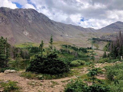
BPX 2-Day: Lake of the Clouds from Gibson Creek TH
Enjoy 2 days in the Sangre de Cristos with this partial loop hike to Lake of the Clouds. The first day requires almost 2500 of climbing, making this a difficult trip. At the top, find a series of small lakes and views of surrounding peaks. Total loop is
Suggested Backpacking Section (BPX) itinerary for 2-day trip to be used for CMC trips led by BPX leaders for BPX members: There are two routes that access Lake of the Clouds, from the Rainbow Trail take the Lake of the Clouds Trail (#1349) or From the Rainbow Trail take the Swift Creek Trail that then intersects with the Lake of the Clouds trail. Together these form a partial loop. The Swift Creek Trail is steeper but more direct.
Day 1. Hike from Gibson Creek TH hike north on the Rainbow Trail (#1336) to the Swift Creek Trail (#1351), turn East and hike to the Lake of the Clouds Trail (#1349), continue to Lake of the Clouds (4.6 miles/2479’). Camping at the lowest of the three lakes, it appeared that there were also good campsites at the middle lake. Note that trees are significantly impacted by beetle kill here -- choose tent sites carefully.
Day 2. Hike from Lake of the Clouds on Lake of the Clouds Trail (#1349) to the Rainbow Trail (#1336) head south to Gibson Creek TH (6 miles/+188’, -2600’)
Driving Directions: Access via Gibson Creek: from Westcliffe; follow Highway 69 north to CR #170, follow this dirt road about 5 miles and turn left at the Forest Service sign for Gibson Ck. Take a right at the next sign and you’ll be on CR #172, follow this to the end of the road (about 3 miles) to get to the Gibson Ck parking area. The access trail to the Rainbow is on the north end of the parking area and goes west about 200 yards until it meets with the Rainbow Trail. The Lakes of the Clouds trailhead (junction with Rainbow Trail) is 1 mile north.
- Suitable Activities: Backpacking
- Seasons: July, August, September
- Weather: View weather forecast
- Difficulty: Difficult
- Length: 11.0 mi
- Elevation Gain: 2,479 ft
- 11,652 ft
-
Land Manager:
U.S. Forest Service
Sangre de Cristo Wilderness Area, San Carlos Ranger District (PSINF)
- Parking Permit Required: USFS Permits & Passes
- Recommended Party Size: 6
- Maximum Party Size: 12
- Maximum Route/Place Capacity: 12
- Trails Illustrated 138
There are no resources for this route/place. Log in and send us updates, images, or resources.
