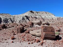
BPX 5-Day: Escalante Petrified Forest State Park Campground
Escalante Petrified Forest State Park campground is ideally situated for exploring Grand Staircase-Escalante National Monument, Capital Reef National Park, Kodachrome Basin State Park, and Bryce Canyon National Park which are all within an hour’s drive. The park is at 5,900' and is 2 miles from Escalante, UT.
There's a good reason why the setting here is so spectacular. The state park and nearby town of Escalante stand watch over the nearby Grand Staircase–Escalante National Monument, which is more than 1.8 million acres of outdoor adventure spread across slot canyons, slickrock and other geologic wonders. Escalante Petrified Forest State Park features colorful deposits of mineralized wood. Visitors will enjoy hiking through the petrified forest located steps from the campsite
In 1872, a member of John Wesley Powell's survey party, Almon Harris Thompson, first explored the Escalante River. He decided to name the area after an explorer named Escalante, which means to escalate upward, like stairsteps, which describes the plateaus surrounding the park.
Guests to this park enjoy hiking, boating, fishing, ice fishing, swimming, wildlife viewing, petrified wood, photography, and camping
Suggested Backpacking Section (BPX) itinerary for 5-day trip to be used for CMC trips led by BPX leaders for BPX members.
- Day 1: Drive to Escalante Petrified Forest Campground. Approx. 8 hours and 500 miles from Golden, CO
- Day 2: Choice of hikes or stay at campsite; enjoy the lake and local walks
- Day 3: Choice of hikes or stay at campsite; enjoy the lake and local walks
- Day 4: Choice of hikes or stay at campsite; enjoy the lake and local walks
- Day 5: Break camp and drive back to Golden.
NEARBY HIKES (in addition to the State and National Parks mentioned above) include:
- Boulder Mail Trail - (mileage/elevation varies)
- Escalante Canyon - 8 miles, 800 ft. elevation gain (varies)
- Golden Cathedral - 10 miles, 1,446 ft. elevation gain
- Harris Wash - 8 miles, 350 ft. elevation gain
- Little Death Hollow - (mileage and elevation vary)
- Lower Calf Creek Falls - 6 miles, 126 ft. elevation gain
- Phipps Arch – 6.4 miles, 603 ft. elevation gain
NOTES:
- Reservations: can be made 4 months in advance for individual sites and 11 months in advance for group site - https://utahstateparks.reserveamerica.com, (435) 826-4466
- Fees: Campground fee $30/night per individual site (includes one vehicle) or $100/night for group site (includes 4 vehicles). Additional vehicles are charged extra. Utah State Park Pass is included in the nightly rate.
- GPS Coordinates: 37°47′16″N 111°37′46″W
- Driving Distance: From Golden 500 miles/8 + hours
- Nearest Medical Clinic (not 24hr): Escalante Health Center, P.O. Box 276, 570 East Moqui Lane, Escalante, Utah 84726. Telephone (435) 826-4374
- Nearest Emergency Room (24 hrs): Intermountain Health Garfield Memorial Hospital Emergency Services, 200 N 400 E St, Panguitch, UT 84759. Telephone (435) 676-8811
- Suitable Activities: Backpacking, Camping
- Seasons: Year-round
- Weather: View weather forecast
- Difficulty: Moderate
- 5,900 ft
- Land Manager: U.S. Forest Service
- Parking Permit Required: State Parks Entrance Fee / Pass
- Recommended Party Size: 8
- Maximum Party Size: 12
- Maximum Route/Place Capacity: 12
- trails illustrated
- 710
- 714
There are no resources for this route/place. Log in and send us updates, images, or resources.
