BPX 3-Day: Twin Lakes, Blue Lake and Peggy Lake
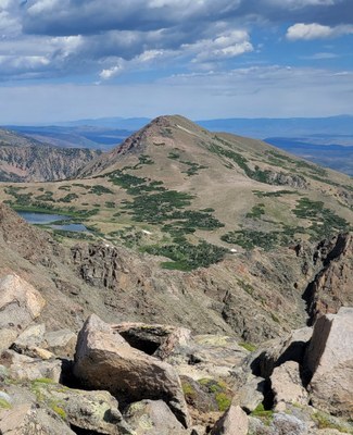
This is a challenging 3 day out and back 22 mile trip in the Mount Zirkel Wilderness Area. Using Twin Lakes as base camp and off trail day hike to nearby Blue Lake and then up to Peggy Lake perched on bench above Blue Lake and tree line and just below the Continental Divide.
Suggested Backpacking Section (BPX) itinerary for 3-day trip to be used for CMC trips led by BPX leaders for BPX members.
Day 1 - Starting at Lone Pine North Trailhead - accessible by car on gravel road - hike north bound on Grizzly Helena trail 1126 just outside wilderness boundary for 6.7 miles with small creek crossings and water at Bear Creek, Monahan Creek, Brown Creek and Ute Creek . This portion of the trail is open to motorcycles but only lightly used as such. Turn left on the Twin Lakes trail 1148 to access upper and lower Twin Lakes and camping at 9,400 feet. Total 8 1/4 miles and 2,200 vertical feet.
Day 2 - From Twin Lakes follow elevation contours cross country north north east to wrap around ridge and drop into Blue Lake basin. Cross Hill Creek and Blue Lake outlet near camp sites and head cross country north up onto bench above Blue Lakes Trail to access ridge line heading west to top of unnamed peak at just over 11,900 feet elevation. After enjoying view retrace path off peak to intersect game trail heading southwest and gradually 700 foot decent to Peggy Lake. Retrace steps back to Twin Lakes. Total 5 1/2 miles and 2,900 vertical feet all off trail with down trees and lower section.
Day 3 - Return by trails to one Pine North Trailhead. Total 8 1/4 miles and
Total 22 miles and 6,300 vertical feet over 3 days.
- Suitable Activities: Backpacking
- Seasons: July, August
- Weather: View weather forecast
- Difficulty: Challenging
- Length: 22.0 mi
- Elevation Gain: 6,300 ft
- 11,900 ft
-
Land Manager:
U.S. Forest Service
Mount Zirkel Wilderness Area, Parks Ranger District (RNF)
- Parking Permit Required: USFS Permits & Passes
- Recommended Party Size: 6
- Maximum Party Size: 12
- Maximum Route/Place Capacity: 12
- Trail Illustrated 116
There are no resources for this route/place. Log in and send us updates, images, or resources.
