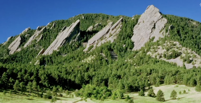
Boulder Flatirons
The five iconic red sandstone slabs known as the Flatirons, run north - south along the eastern slope of Green Mountain in Southwest Boulder.
See Boulder Open Space. The Flatirons are surrounded by many trails and climbing routes. including these trailheads: NCAR, Enchanted Mesa, Gregory Canyon, Chautauqua, Realization Point, and Lost Gulch.
Alternate titles -
Flatirons Vista Hike
Flatirons Loop
Woods Quarry
Flatirons
Chautauqua Park
- Suitable Activities: Biking, Climbing, Hiking, Snowshoeing
- Seasons: Year-round
- Weather: View weather forecast
- View avalanche forecast.
- Land Manager: Boulder County Parks & Open Space
- Parking Permit Required: Other
- Recommended Party Size: 12
- Maximum Party Size: 12
- Maximum Route/Place Capacity: 12
This is a list of titles that represent the variations of trips you can take at this route/place. This includes side trips, extensions and peak combinations. Not seeing a title that fits your trip? Log in and send us updates, images, or resources.
- Flatirons Vista Hike
- Flatirons Loop
- Woods Quarry
- Chautauqua Park
- Flatirons
There are no resources for this route/place. Log in and send us updates, images, or resources.
