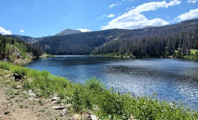
Boss and Hunt Lakes Trail
The trail is a 7.5 mile out and back that starts at an elevation of 9,719 ft with an elevation gain of 1,955 ft. Considered a moderately difficult class 1. On average it takes a little over 4 hours to hike.
Set in thick forest, between Salida and Monarch Pass, the trail follows a steep 4WD road (FR 230) for 1.2 miles then joins with the CDT continuing to Boss Lake Reservoir. Established by miners, remnants of the former mining operation remain. After reaching the reservoir, the trail follows the CDT for another 2.2 miles to Hunt Lake. This section of the CDT was, and some sections may still be, considered a black diamond single track. In 2022, volunteers with the Colorado Trail Foundation reworked portions of the trail to add switchbacks.
- Suitable Activities: Backpacking, Camping, Exploring Nature, Fly Fishing, Hiking, Snowshoeing
- Snowshoeing Category: Intermediate
- Seasons: June, July, August, September, October
- Weather: View weather forecast
- Difficulty: Mod B
- Length: 7.5 mi
- Elevation Gain: 1,945 ft
- 11,476 ft
-
Land Manager:
U.S. Forest Service
Sangre de Cristo Wilderness Area, Salida Ranger District (PSINF)
- Parking Permit Required: USFS Permits & Passes
- Recommended Party Size: 12
- Maximum Party Size: 12
- Maximum Route/Place Capacity: 12
- AllTrails
- COTREX
- caltopo
- caltopo
This is a list of titles that represent the variations of trips you can take at this route/place. This includes side trips, extensions and peak combinations. Not seeing a title that fits your trip? Log in and send us updates, images, or resources.
- Boss Lake
- Hunt Lake
There are no resources for this route/place. Log in and send us updates, images, or resources.
