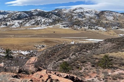
Bobcat Ridge Natural Area
Near Fort Collins & Loveland, Bobcat Ridge Natural Area has grassy valleys, foothills, ponderosa pines, stunning red rock cliffs and more. Bobcat Ridge is home to elk, wild turkey, mountain lions and other wildlife. Several historic homestead sites dot the landscape.
Bobcat Ridge Natural Area is an on-trail-only natural area.
Trails (Map):
- The Valley Loop Trail: Easy to moderate, 4-mile loop.
- Eden Valley Spur: Moderate, an out and back route, 1.3 miles along the valley bottom.
- Ginny Trail: Very difficult, 5.4 miles, climbs 1,500 feet. Open for hiking and mountain biking, closed to horses.
- D.R. Trail: Moderate, 3.4 miles long, climbs 1,100 feet. Open to equestrians and hikers, temporarily open to cyclists for both downhill and uphill use.
- Powerline Road: Difficult, 1.5 miles long. Climbs steeply with loose rocks so not recommended for horses, uphill only for cyclists.
- On the Rocks Trail: Very difficult, 1 mile. Downhill use only. Open to hikers and cyclists, recommended for expert riders only (rated double black diamond), closed to horses.
NOTE(S):
- Bobcat Ridge Natural Area Ranger Office: (970) 461-2700
- Bobcat Ridge Natural Area brochure
- Know before you go safety and recreation information.
- In alignment with the Americans with Disabilities Act (ADA), service animals that have been trained to assist a person with a disability are always allowed.
- This is one of the few Fort Collins natural areas on which dogs are not allowed.
Direction(s):
- From Fort Collins, take Harmony Road west, it turns into CR 38 E. Follow CR 38 E to Masonville. Go left (south) at the Masonville Mercantile onto CR 27. Follow CR 27 about 1 mile to CR 32 C, head west about 1 mile to the Bobcat Ridge parking lot.
- From Loveland, go west on Highway 34 about 4.5 miles west of Wilson Avenue. Turn north on CR 27 by Big Thompson Elementary and drive 4.5 miles. Turn left on CR 32C and go 1 mile west to the Bobcat Ridge parking lot.
-
Address: 10184 West County Road 32C, Loveland, CO
- Suitable Activities: Hiking
- Seasons: Year-round
- Weather: View weather forecast
- Difficulty: Easy to Moderate, Easy to Moderate
- Land Manager: Land Manager Varies
- Parking Permit Required: Other
- Recommended Party Size: 8
- Maximum Party Size: 12
- Maximum Route/Place Capacity: 12
This is a list of titles that represent the variations of trips you can take at this route/place. This includes side trips, extensions and peak combinations. Not seeing a title that fits your trip? Log in and send us updates, images, or resources.
- Bobcat Ridge Natural Area - D.R. Trail
- Bobcat Ridge Natural Area - Eden Valley Spur
- Bobcat Ridge Natural Area - Ginny Trail
- Bobcat Ridge Natural Area - On the Rocks Trail
- Bobcat Ridge Natural Area - Powerline Road
- Bobcat Ridge Natural Area - Valley Loop Trail
There are no resources for this route/place. Log in and send us updates, images, or resources.
