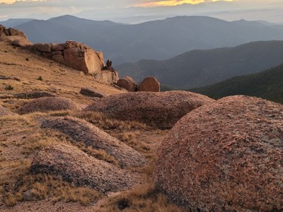
Bison Peak
Moderately difficult peak depending on the route selected. Peak is 12,432 ft. Around 12-14 miles round trip and 2,470 - 3,736 ft. of elevation gain depending on the route taken.
The two day trip trails are the Brookside McCurdy Trail and the Ute Creek Trail to reach Bison Peak. Beautiful rock formations at the top.
Hike to Bison Peak, the highest summit in the Tarryall Mountains. Start at Ute Creek Trailhead following Ute Creek Trail #629 to enter the Lost Creek Wilderness Area. While not very step at the beginning, the gain increases and remains continuously challenging to the summit. Follow Ute Creek Trail # 629 until the junction with the Brookside-McCurdy Trail #607. Turn right onto Brookside-McCurdy trail following switchbacks that lead above timberline up to the final saddle before the summit. Leave the fading trail hiking on tundra northeast towards the rock towers. Gain the summit by continuing on the tundra or via an easy class 1-2 scramble.
- Suitable Activities: Hiking
- Seasons: Year-round
- Weather: View weather forecast
- View avalanche forecast.
- 12,432 ft
-
Land Manager:
U.S. Forest Service
Lost Creek Wilderness Area, South Platte Ranger District (PSINF)
- Parking Permit Required: USFS Permits & Passes
- Recommended Party Size: 12
- Maximum Party Size: 15
- Maximum Route/Place Capacity: 15
This is a list of titles that represent the variations of trips you can take at this route/place. This includes side trips, extensions and peak combinations. Not seeing a title that fits your trip? Log in and send us updates, images, or resources.
- Bison Peak via Brookside McCurdy Trail
- Bison Peak via Ute Creek Trail
There are no resources for this route/place. Log in and send us updates, images, or resources.
