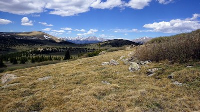
Ben Tyler Trail
USFS Trail #606. 11.4 mile NE/SW trail that intersects 285 and the Colorado Trail.
Ben Tyler Trail - South/Rock Creek TH
To enter this end of the Ben Tyler Trail (#606), park at the Rock Creek TH and follow the Colorado Trail east for for about .6 miles, until you reach the signed junction with Ben Tyler Trail, where that trail officially starts. Follow the trail until you reach the top of a saddle, which is in a forested area at about 11,690.' Thereafter the trail will descend to down to US-285 or you can head back to the Rock Creek TH.
Ben Tyler Trial - North/Ben Tyler TH
For further information and any restrictions see: Pike-San Isabel National Forests & Cimarron and Comanche National Grasslands - Ben Tyler Trail #606 (usda.gov)
- Suitable Activities: Hiking, Snowshoeing
- Seasons: Year-round
- Weather: View weather forecast
- Length: 12.0 mi
- 9,750 ft
-
Land Manager:
U.S. Forest Service
Lost Creek Wilderness Area, South Platte Ranger District (PSINF)
- Parking Permit Required: USFS Permits & Passes
- Recommended Party Size: 12
- Maximum Party Size: 15
- Maximum Route/Place Capacity: 15
This is a list of titles that represent the variations of trips you can take at this route/place. This includes side trips, extensions and peak combinations. Not seeing a title that fits your trip? Log in and send us updates, images, or resources.
- Ben Tyler Trail - North/Ben Tyler TH
- Ben Tyler Trail - South/Rock Creek TH
There are no resources for this route/place. Log in and send us updates, images, or resources.
