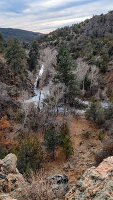
Beaver Creek Wilderness Study Area
Wilderness Study Area and State Wildlife Area in the foothills west of Penrose, CO.
A valid fishing, hunting, or SWA pass are required to hike in this area. Along with beautiful views, this trail, located in the foothills has lots of cactus, a few stream crossings (bring your water shoes), some exposure, and some history. It can normally be done year round. In the winter Beaver Creek may be frozen over. In the summer the area can be hot, bring plenty of water. We share these foothills with deer, bear, mountain lions, and snakes. Additional information can be found at https://cpw.state.co.us/swa/Beaver%20Creek%20SWA
Directions:
Turn north off of Hwy 50 to Hwy 67 (Phanton Canyon Rd.), then go N 2 Miles to CR 123, then E 0.2 miles to CR 132, and then N 9 miles to the parking lot. Grated road and nice parking lot.
Beaver Creek Loop: 9 miles, 1,696 feet of elevation gain
The loop combines three trails: Beaver Creek, Powerline and Trail Gulch.
- Suitable Activities: Backpacking, Hiking
- Seasons: Year-round
- Weather: View weather forecast
- 7,569 ft
-
Land Manager:
Bureau of Land Management
Royal Gorge Field Office
- Parking Permit Required: State Wildlife Area Pass
- Recommended Party Size: 12
- Maximum Party Size: 12
- Maximum Route/Place Capacity: 12
- AllTrails
- COTREX
- Gaia
There are no resources for this route/place. Log in and send us updates, images, or resources.
