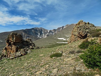
Battle Mountain Traverse
The route leaves the standard East Longs Peak Trail, climbs through Jim's Grove to a scenic highpoint, then crosses Battle Mountain before descending to Storm Pass and rejoining the standard trail system back to the trailhead thereby making a large loop.
Please view this document with everything you need to know about Rocky Mountain National Park
For further information and any restrictions see: Longs Peak - Keyhole Route - Rocky Mountain National Park (U.S. National Park Service) (nps.gov)
Rules & Regulations - Rocky Mountain National Park (U.S. National Park Service) (nps.gov)
Directions to trailhead: East Longs Peak Trail – Longs Peak Trail – Keyhole Route – Shelf Trail - Google Maps
This Moderate B hike of 8 miles gains about 2,700' as it traverses Battle Mountain in Rocky Mountain National Park.
Starting at the Longs Peak Ranger Station, our route takes us up the historic East Longs Peak Trail. This is the route typically used, either all or in part, by just about everyone climbing Longs Peak. The route climbs steadily through the forest but the views open up dramatically once above treeline. The East Face of Longs Peak and the mass of Mount Meeker come into view. Just above treeline, our route will leave the ELPT and get onto the original trail to Longs Peak that went through Jim's Grove. We'll stop at Point 11408 along the way and enjoy the excellent views. From there, the route just goes across open tundra to the broad 12,044' summit of Battle Mountain. Continuing north, we'll head for Point 11909 and take a compass bearing on nearby Estes Cone that will guide us down through dense forest to Storm Pass.
At Storm Pass, we'll encounter numerous trails but will again descend through the forest to the site of the old Eugenia Mine operation. Relics still exist. From the actual mine site, we'll follow the creek down to the site of an old cabin and rejoin the standard trail system for the walk back to the trailhead.
This hike is better done in summer but can be done as a winter snowshoe. In winter, be prepared for windy, cold, and harsh conditions. Deep snow may be present in the trees.
To review the Trip Leader Checklist see: Shared R:P+Trip Leader Activity Checklists - Google Docs
- Suitable Activities: Hiking, Snowshoeing
- Snowshoeing Category: Intermediate
- Seasons: Year-round
- Weather: View weather forecast
- Difficulty: Mod B
- Length: 8.0 mi
- Elevation Gain: 2,700 ft
- 12,044 ft
-
Land Manager:
National Park Service
Rocky Mountain National Park
- Parking Permit Required: National Park Entrance Fees
- Recommended Party Size: 10
- Maximum Party Size: 12
- Maximum Route/Place Capacity: 12
There are no resources for this route/place. Log in and send us updates, images, or resources.
