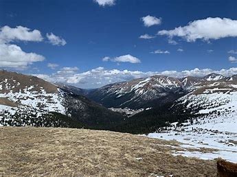
Jones Pass
Jones Pass Road is accessible to most vehicles. Jones Pass is along the Continental Divide. The road is 7 miles out and back. Activities year round.
For further information see: Arapaho & Roosevelt National Forests Pawnee National Grassland - Jones Pass Trailhead (usda.gov)
Travel the first mile along the Jones Pass Road to the top of the valley floor, then leave the road and proceed north, then northwest, along the West Fork of Clear Creek and ascend toward the Continental Divide. This route can connect to the Continental Divide Trail and the Mt. Nystrom Trail once the Divide is reached.
Alternate title data:
Jones Pass Road: This is specific to staying on the road with a larger party than is allowed on the Forest Service trails surrounding the road. Park at the Mine lot and walk up the road.
- Suitable Activities: Backcountry Skiing/Splitboarding, Backpacking, Biking, Camping, Climbing, Hiking, Snowshoeing
- Seasons: Year-round
- Weather: View weather forecast
- Length: 7.0 mi
- Elevation Gain: 1,600 ft
- 12,454 ft
-
Land Manager:
U.S. Forest Service
Clear Creek Ranger District (ARNF)
- Parking Permit Required: USFS Permits & Passes
- Recommended Party Size: 12
- Maximum Party Size: 15
- Maximum Route/Place Capacity: 15
This is a list of titles that represent the variations of trips you can take at this route/place. This includes side trips, extensions and peak combinations. Not seeing a title that fits your trip? Log in and send us updates, images, or resources.
- Jones Pass Road
- Mt. Nystrom and Vasquez Peak
There are no resources for this route/place. Log in and send us updates, images, or resources.
