Abyss Lake Trail
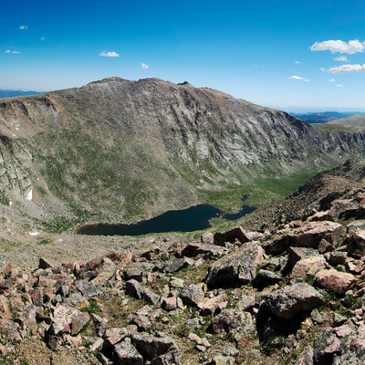
Abyss Lake is nestled in a high glacial cirque between Mt. Bierstadt and Mt. Evans in the Mt. Evans Wilderness. Before ending at Abyss Lake this trail reaches Helms Lake.
Before creating a trip, click “Activities” below to make sure there isn’t already a trip booked to the same place on the same date.
For further information and any restrictions see: Pike-San Isabel National Forests & Cimarron and Comanche National Grasslands - Abyss Lake Trail #602 (usda.gov)
Directions to parking lot: Abyss Trailhead - Google Maps
Alternate title data:
Abyss Lake Trail to Abyss Lake - 17 miles, 3,389 feet elevation gain.
Abyss Lake Trail to Helms Lake - 12 miles, 2,400 feet elevation gain
To review the Trip Leader Checklist see: Shared R:P+Trip Leader Activity Checklists - Google Docs
- Suitable Activities: Backpacking, Hiking, Snowshoeing
- Seasons: Year-round
- Weather: View weather forecast
-
Land Manager:
U.S. Forest Service
Mount Evans Wilderness Area, South Platte Ranger District (PSINF)
- Parking Permit Required: USFS Permits & Passes
- Recommended Party Size: 12
- Maximum Party Size: 12
- Maximum Route/Place Capacity: 12
- COTREX
This is a list of titles that represent the variations of trips you can take at this route/place. This includes side trips, extensions and peak combinations. Not seeing a title that fits your trip? Log in and send us updates, images, or resources.
- Abyss Lake TH - Abyss Lake Trail to Helms Lake
- Abyss Lake TH - Abyss Lake Trail to Abyss Lake
- Abyss Lake TH - Abyss Lake Trail
There are no resources for this route/place. Log in and send us updates, images, or resources.
