Trip
Hiking – Thunder Butte and Sheep Nose (North Summit)
Thunder Butte and Sheep Nose (North Summit)
- Mon, Oct 10, 2022
- Bobcats Section
- Hiking
- Adults
- Challenging
- Mileage: 7.0 mi
- Elevation Gain: 1,800 ft
- High Point Elevation: 9,836 ft
- Pace: moderate (avg moving speed 1.5 - 1.7 mph)
- 2 (11 capacity)
- Cancellation & Refund Policy
We will meet in the parking lot of Halftime Help Stadium at Redstone Park in Highlands Ranch at 7:00am for a PROMPT 7:15am departure. This is Highlands Ranch's high football stadium, and is located along Town Center Blvd - just south of C-470 and Santa Fe Dr (US85). Here's a Google Maps link to the meeting place: https://goo.gl/maps/qdpTBKUn8PPbU7wV6
The trailhead is along W 9-J Road, just west of Westcreek. Westcreek is 14 miles south of Deckers along CO 67. It takes about 1 hour, 20 minutes to get to the trailhead
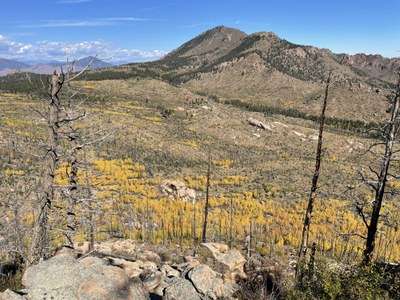
Thunder Butte and Sheep Nose are two of those big granite pop ups in the Hayman burn area south of Buffalo Creek. Thunder Butte is the high point of Douglas County and is so listed in a Colorado county highpointer book.
The first part of this trail is faint. Once into the Pine Trees on Thunder Butte's SW slope, the faint trail ceases to be, so we will bushwhack northeast up to the saddle between Thunder Butte and a sub peak. From the saddle, there will be bushwhacking and some minor scrambling as we follow the ridge northwest up to Thunder Butte's summit. At the summit we are rewarded with sweeping views - of Bison Peak, McCurdy Peak, and the Lost Creek Wilderness to the west, the Hayman Burn to the southwest, the Rampart Range to the east, Pikes Peak to the south, and other well visited peaks by CMCers to the north.
We will return to the trailhead, then head southeast to Sheep Note. We will stay along the bottom of the North cliff face until we come around the East face. Continue up while heading South along the East face until the summit is reached. Sheep Nose provides breathtaking views of Pikes Peak and the surrounding land. There is some Class 2 scrambling (and maybe Class 3 depending on the exact route taken) on this portion of this trip.
This is a CMC Bobcats trip
The Bobcats’ mission is to ensure a variety of challenging CMC trips, mostly on weekdays, all year long, for our mostly age 50+ constituents. We don’t have dues or elections and we invite all CMC members to sign up for any Bobcats trip. The Bobcats publish an email newsletter on the 15th of each month, which includes the upcoming month’s trips that have just been opened
LIMITED TO MEMBERS WHO ARE FULLY VACCINATED AND BOOSTED FOR COVID-19
The round-trip driving distance from the meeting place to/from the trailhead is 95 miles.
There will be an optional celebratory stop after the hike.
Required Equipment
.In addition to the ten essentials, make sure you have sturdy shoes (boots are preferred) for the off-trail portions of this hike. Gloves will be useful for the scrambling portions.
