Trip
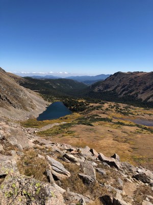
Hiking – DEVILS THUMB PASS This is an out and back hike of 7.6 miles roundtrip and elevation gain of 2300 feet. The TH is located about 8 miles from Fraser on County Road 8. We will hike to the Devils Thumb pass where we can see Devils Thumb Lake but will not descend to Devils Thumb Lake).
DEVILS THUMB PASS This is an out and back hike of 7.6 miles roundtrip and elevation gain of 2300 feet. The TH is located about 8 miles from Fraser on County Road 8. We will hike to the Devils Thumb pass where we can see Devils Thumb Lake but will not descend to Devils Thumb Lake).
- Wed, Aug 24, 2022
- Rocky Mountain Over the Hill Gang
- Hiking
- Adults
- Moderate
- Mileage: 7.6 mi
- Elevation Gain: 2,250 ft
- High Point Elevation: 11,700 ft
- Pace: moderate
- 3 (11 capacity)
- Cancellation & Refund Policy
The trail ascends gradually at the beginning and becomes steeper as we ascend to the pass which is above treeline. Several creek crossings during the first part of the hike.
Meet at Wooly Mammoth Park-n-Ride, Section BB, at 6:20 am to arrange carpools. Roundtrip driving distance is 120 miles - bring $12 to reimburse your driver. Please bring a mask for carpooling if needed.
This trail is in the Indian Peaks Wilderness area and I have secured a 'Group Day Use' pass for this trip.
An email will be sent on Tuesday, Aug 23 to all participants concerning weather, additional gear, etc.
Required Equipment
10 essentials, bug spray, lunch.

