Trip
Hiking – Palmer Lake Reservoir Trailhead
Chautauqua Mtn and Palmer Lake Reservoir Loop
- Wed, Oct 25, 2023
- Rocky Mountain Over the Hill Gang
- Hiking
- Adults
- Moderate
- Moderate
- Mileage: 6.0 mi
- Elevation Gain: 1,600 ft
- High Point Elevation: 8,400 ft
- Pace: Moderate (1.5 - 1.8 avg moving speed)
- 3 (9 capacity)
- Cancellation & Refund Policy
Meet at 8:00AM in the Cabelas parking lot at Ridgegate and I-25, specifically in the northwest section of the parking lot near the Cabela's, so we can leave no later than 8:15AM. Here is a Google Maps link to the meeting place: https://goo.gl/maps/wWCXBUwvW7D5SDSg6 DO NOT PARK in the parking lot close to the Sierra Restaurant or the hotel!
The Trailhead is the Palmer Lake Reservoir Trailhead. There is a $5 per car parking fee for non-residents of the town of Palmer Lake. Here’s a Google Maps link to it: https://goo.gl/maps/NjGvK7zqd8qwx7Qv6
THIS HIKE IS FOR RMOTHG MEMBERS ONLY
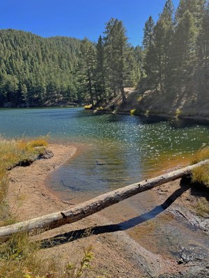
This is a loop hike. From the Palmer Lake Reservoir Trailhead, we will head up the north slope of Chautauqua Mountain, where we will be rewarded with great views of the Rampart Range. This is the steepest section of the hike, it is on a good social trail, but we will take this section slowly. We will then walk south along the ridgeline and multiple summits of Chautauqua Mountain down to a saddle. First, from the saddle we will walk on a road up to a rock formation erroneously called Balanced Rock, then we will return to the saddle. From there, we will walk along the 4WD road, through an aspen grove, to the Upper Palmer Reservoir where we will enjoy our lunch break. After lunch we walk down the Palmer Lake Reservoir road, past the Lower Reservoir, back to the trailhead.
Required Equipment
Be sure to bring your 10 essentials. If you use hiking sticks, bring them.
