Trip
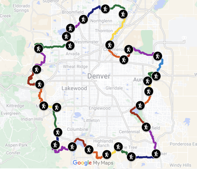
Hiking – Orbital Trail - Segment 13
For Rocky Mountain Over the Hill Gang members ONLY. We will hike segment 13 of the Denver Orbital Trail (DOT) through Cherry Creek State Park on the Cherry Creek Trail . We will be hiking from north to south. Suzanne Dysard will be leading this hike from south to north on the same day. We should be able to meet in the middle for lunch.
- Wed, Feb 12, 2025
- Rocky Mountain Over the Hill Gang
- Hiking
- Adults
- Moderate
- Moderate
- Mileage: 9.5 mi
- Elevation Gain: -50 ft
- High Point Elevation: 5,680 ft
- Pace: 2.1
- 2 (10 capacity)
- FULL (2 capacity)
- Cancellation & Refund Policy
ARRIVE BY 9:00 am TO DROP SHUTTLE CARS at the Arapahoe Rd TH for the Cherry Creek Trail.
https://maps.app.goo.gl/oEVXsAXwjLWzpW419. We will drive shuttle cars north to our starting point at the Cherry Creek State Park Visitor Center https://maps.app.goo.gl/ogswesKkiv6B9QFZ9.
Shuttle drivers should confirm their car has the state park Keep Colorado Wild Pass that is offered with their annual auto registration or a $10 -12 day park entry pass will be required. The pass goes with the car, not with the owner.
Since the distance between trailheads for the shuttle is short and half of us will be driving one direction or the other, there will be no carpool cost sharing for the shuttle.
(If you are interested in carpooling from somewhere further west, so indicate in a Registration Note and I will let the others know about that interest, but it will be up to you to arrange any carpool and the sharing costs.)
The first part of the hike will be around and over the Cherry Creek Reservoir and Dam, and then through the State Park along the Cherry Creek Trail. Toward the end we will drop briefly into a neighborhood greenway with sidewalks before arriving back at the Arapahoe Rd TH. Drivers with cars there will shuttle the others back to their cars at the Visitor Center.
See the map and download the gpx track at AllTrails but note that our group will be following the route shown at AllTrails IN REVERSE, plus I have added an extra mile to account for the walk from the visitor center parking (only parking available) to where the official segment starts/ends. https://www.alltrails.com/explore/map/segment-13-arapahoe-road-trailhead-to-cherry-creek-state-park-8169e05?u=i&sh=xvzrld
There are toilets at both the Visitor Center and the Arapahoe Rd TH. And several along the way as we walk through the park.
Dress appropriately for the weather, including sunscreen and a hat, plus wind clothes. Bring a lunch and plenty of water. Expect a cold start. Carry microspikes because they may be required.
This route is exploratory for the trip leaders. We will write a day or before trip day to review the weather and any logistical adjustments.
Required Equipment
Dress appropriately for the weather, including sunscreen and a hat, plus wind clothes. Bring a lunch and plenty of water. Expect a cold start. Carry microspikes because they may be required.
