Trip
Hiking – Noddle Heads
This hike is for RMOTHG members only. This is a hike to a series of 4 rock pillars on a ridgeline in the Rampart Range, that are better known for their rock climbing opportunities
- Wed, Oct 23, 2024
- Rocky Mountain Over the Hill Gang
- Hiking
- Adults
- Easy
- Moderate
- Mileage: 7.0 mi
- Elevation Gain: 1,000 ft
- High Point Elevation: 8,110 ft
- Pace: Moderate (1.8 - 2.0 avg moving speed)
- 3 (6 capacity)
- FULL (2 capacity)
- Cancellation & Refund Policy
We will meet in Sedalia a few minutes before 8:30am, specifically along N Plum Avenue, across from where Gabriels Restaurant used to be, in the parking area across the street from the restaurant. Here is a Google Maps link to the meeting location: https://maps.app.goo.gl/b9s8j4nEC4UJPk686
The trailhead and parking area is on CO 67, 17 miles west of Sedalia, 4 miles south of Sprucewood. The coordinates for the trailhead are 39.31474, -105.13408. You can also use this Google Maps link: https://maps.app.goo.gl/fGSTyQf3bgVHnsQdA
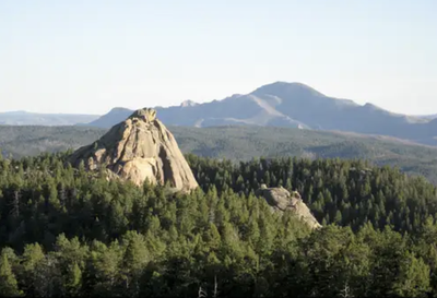
The Noddle Heads are a series of four spires and rock towers on a prominent ridgeline in the Rampart Range - in the Pike National Forest. While the Noddle Heads are known for their rock climbing, we will be hiking by them, enjoying the rock spires along with the sweeping views to the west.
The first 2 miles of this hike are on an old Forest Service Road up to the ridgeline. The rest of the hike is mostly along a ridge line on what is best described as a casual or use trail, and some will be off-trail through the forest. Some of this hike will be on uneven terrain.
After the hike, there will be an optional visit to Bud's Cafe and Bar, a long-time well-known Sedalia (and Douglas County) bare-bones joint, popular for its hamburgers offered with pickles, onion & chips.
Required Equipment
Bring good shoes, have good sun protection (a brimmed hat, sunglasses, and sunscreen, 2 liters of water, and hiking sticks (if you use them).
