Trip
Hiking – Mount Irving Hale, 11,754 ft, 9.6 miles, 3500 ft.
Mount Irving Hale, 11,754 ft, 9.6 miles, 3500 ft.
- Wed, Sep 27, 2023
- Pikes Peak
- Hiking
- Adults
- Challenging
- Mileage: 9.6 mi
- Elevation Gain: 3,500 ft
- High Point Elevation: 11,754 ft
- Pace: 2.0
- 3 (8 capacity)
- Cancellation & Refund Policy
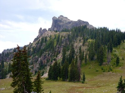
You’d be forgiven for not knowing where Mt. Irving Hale is, or that it even exists. The mountain is hidden amongst a sea of others that make up the margins of Grand County. Its elevation, a lowly 11,754 ft, doesn’t get a lot of attention except amongst the most dedicated outdoor folk of the region. Yet, Mt. Irving Hale is unique for a few reasons. Despite its lower elevation, it still gets above treeline, and because it sits back from the main ridges of the Indian Peaks, its summit views are outstanding.
From the Roaring Fork Trailhead climb the very steep Roaring Fork Trail through the boulders. Once you bend away from the lake and begin paralleling the Roaring Fork, things mellow out. The trail will cross the stream at a lovely spot with large trees and continue to parallel the mountain waterway as you thread higher. There aren’t many long-distance views to be had in this section, but the sound of the cascading water is lovely, and the trail is quite manageable. Occasionally, you’ll see a set of cliffs and ridgelines to the right. You need to travel beyond them before reaching the next trail junction, roughly 2.6 miles into your journey. You’ll re-cross the Roaring Fork, so you’re on its eastern side and then at approximately 3.5 miles you’ll come to the Watanga and Roaring Fork Junction at 9,900'. Take a right to follow the Roaring Fork Trail and begin your biggest climb of the day. You then crest a roll of land and meander through an open forest before sighting some small meadows. At first, they are sporadic, but soon the meadows increase in frequency. Eventually, the trees peel back to reveal an open shoulder with stupendous views. This is the high point of the trailed portion. You will know you are here when you are in a wide-open area at treeline (11,200) and you are relieved from the steep switchbacks that you previously hiked.
From the saddle leave the trail and hike south, keeping to the ridge crests. Once you pass through some tree groves, which can be surprisingly thick, you’ll be able to zero in on your target. Once you break through the final trees and reach the broken rocks near the top, the views will start to open up again. Now, there are plenty of scrambling options up the rocks on Irving Hale.
Generally, there are third class and a few 4th class variations the closer you stay to the crest. The easiest routes are to the right and circle around the major difficulties. Even if you decide to skip the ridgeline, it’s fun to peer over it and stare at the full extent of the dramatic cliffs.
Leader's Note - The leader has not done this hike before, so expect a little adventure.
Roaring Fork Trailhead, at 7:30.
From US 40 near Granby drive 5 miles North on US 34. Turn East towards Arapaho Bay and continue on for 9.4 miles along the South side of Lake Granby to Big Rock Campground. The paved road quickly turns into a well-groomed dirt road. On the West end of Lake Granby turn left and drive .08 miles to the trailhead located on the north side of the road.
Required Equipment
TK
