Trip
Hiking – Columbine Lake Trail (Silverton area) - Locals Favorite!!
Columbine Lake Trail (Silverton area) - Locals Favorite!!
- Sat, Aug 10, 2024
- Western Slope
- Hiking, Exploring Nature, Environmental Awareness
- Adults, Youth, Singles, Families
- Moderate
- Moderate
- Mileage: 8.0 mi
- Elevation Gain: 2,295 ft
- High Point Elevation: 12,685 ft
- Pace: 2 mph
- 8 (9 capacity)
- Cancellation & Refund Policy
8:00 AM Meet-up at Columbine Lake Trailhead #509 between Ouray and Silverton. We'll start the hike at 8:30 AM to get a jumpstart on any afternoon storms.
From the intersection of US 550 and Greene Street (main drag) in Silverton, go north on 550 for 5 miles and turn left off the paved hwy onto Ophir Road. Cross Mineral Creek, make a left-hand switchback, then look for a road (FS Rd 820) heading to the right 0.4 mi from the hwy. Go up this narrow, bumpy road for 0.8 mi to the trailhead. (N 37 51.620, W 107 43.681, 10,390 ft). Parking can be a little challenging, there is more parking room just north of the trailhead. You can also park at the bridge at Mineral Creek but this adds 1.6 mi. We might consider shuttling from this spot, if needed.
- CMC Pack Guide Best Durango and Silverton Hikes #7. This moderate 8 mile roundtrip hike is a local favorite. We'll be looking for mushrooms and wildflowers along this 4 to 6.5 hour hike with a plan to eat/break at the lake. Start at 10,390 ft, lake is at 12,685 ft.
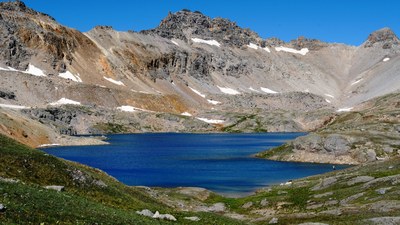
Be ready to climb since the trail begins with a number of steep switchbacks. Hiking/trekking poles might come in handy. We'll be rewarded with beautiful tundra carpeted with wildflowers and grass where we'll saunter the rest of the way to Columbine Lake under the gaze of Lookout Peak and other 13ers. Depending on hiking group dynamics, we will consider addition exploring around, near, and possibly above the lake.
Required Equipment
Rain gear and trekking/hiking poles are recommended. This is especially true if we experience wet trail conditions.
