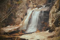
Colorado Waterfall Hikes, 2nd edition, the latest guidebook to be published by CMC Press, describes 52 enjoyable hikes to beautiful waterfalls around the state.
Order your copy of Colorado Waterfall Hikes 2nd edition today!
*****
MAXWELL FALLS
Arapaho National Forest
Difficulty Moderate
Round-trip Distance 3.8 miles
Hiking Time 1.5–3 hours
Starting Elevation 7,800 feet
Highest Elevation 8,300 feet
Maps Trails Illustrated #100: Boulder, Golden
Restrictions Dogs are allowed but must be leashed at all times. Violators will be prosecuted. $1,000 maximum fine. Please clean up after your pet, take the bag(s) with you, and dispose of it properly.
For More Info Arapaho National Forest, Clear Creek Ranger District, 303-567-3000
COMMENT: This is a particularly nice hike on hot summer days. The trail travels through a slice of the Arapaho National Forest south of the town of Evergreen. Its ups and downs will provide you with a good workout and reward you with a cooling rest next to or above Maxwell Falls. The waterfalls are on a section of Maxwell Creek that originates on the eastern flanks of 10,760-foot Black Mountain to the southwest and flows northeast, joining Cub Creek near South Brook Forest Road (CR 78). The best time to explore this hike is on weekdays, if you prefer to share the trail with fewer people.
GETTING THERE: Head 1.0 mile south of Evergreen on Jefferson County Road 73 (CR 73). Turn right (west) onto South Brook Forest Road and drive 3.6 miles to a small parking lot on the left (south) side of the road. Limited additional parking is available along South Brook Forest Road. Observe parking signs to avoid receiving a fine. GPS: N39° 34.95' / W105° 21.65'. You can also reach this trailhead by traveling north on CR 73 from Conifer and US 285.
THE HIKE: This hike begins at the Lower Maxwell Falls Trailhead, at 7,800 feet in elevation. It is possible to reach the waterfalls from the Upper Trailhead as well, but that makes the hike much shorter and less interesting.
The Maxwell Falls Trail begins in the southwest corner of the parking lot, to the left of the trailhead sign. Please read and follow all of the information on the sign. The trail heads up a northeast-facing gully and has a gentle, steady uphill grade with a nice dirt surface and large rocks sprinkled about. It levels out for a while then crosses a drainage after 0.7 mile, switchbacks to the right, and heads uphill again. After a left switchback, it continues up to a saddle on a ridge between the gully and the canyon to the west. There appears to be a five-way trail junction at this saddle, but only a small sign with “TRAIL” and an arrow pointing straight ahead is there to direct you. Continue straight across the saddle.
The trail now descends into the canyon with a gentle, winding traverse of the hillside, and follows along Maxwell Creek, crossing it once (at mile 1.4). After crossing the wooden bridge, turn left and continue up the Maxwell Falls Trail; the Cliff Loop Trail goes to the right. The trail then ascends the west side of the canyon as it becomes steeper and rockier. You’ll pass small, pretty cascades to the left of the trail, then large boulders and a cliffband on the right.
At 1.7 miles, the trail curves left and heads south. You’ll soon notice a faint trail heading downhill to the creek on your left. At this point, you have the option of hiking down to the base of the waterfalls on this separate trail, or to the top of the waterfalls from an overlook on the main trail. If you want to reach the base of Maxwell Falls, take this trail down and follow it about 150 feet along the creek to the south. GPS: N39° 34.09' / W105° 22.67'. Return to the main trail. Otherwise, continue on the main trail as it switchbacks to the right. Continue uphill and, after about 350 feet, veer to the left to reach the overlook with a view of the waterfalls from above. To reach the top of the falls, continue south from the overlook about another 120 feet. GPS: N39° 34.09' / W105° 22.68'. Sit and enjoy a rejuvenating rest.
Return the way you came.
 Sarah Gorecki
