Round Trip: 5.5 miles
Difficulty: Moderate
Skill Level: Novice
High Point: 9,800 feet
Elevation Gain: 923 feet
Avalanche Danger: Low to considerable; can be avoided
Map: Trails Illustrated #102, Indian Peaks, Gold Hill
Contact: Boulder County Open Space and Boulder Ranger District, Roosevelt National Forest
COMMENT:
The Hessie Valley is a beautiful riparian area of Middle Boulder Creek, located just west of the town of Eldora. You will see rock formations, peak views, and moose, if you are lucky. It is a good route for family excursions, as hiking part of the trail is worthwhile. This is one of two Lost Lake trails covered in this book. The other is North Fork Trail near Estes Park. This is a much shorter and easier route and it's relatively close to the Denver-Boulder areas, making it very popular. Either plan to arrive early or visit during the week to avoid crowds and garner a close-in parking spot.
GETTING THERE:
From Nederland, go left/south through the roundabout, on to Peak to Peak Highway 72 for around 1 mile and turn right onto County Road 130. In approximately 2 miles you will see the turnoff on the left on CR 140 uphill for Eldora Mountain Resort; don't turn, go straight. The town of Eldora is another 2 miles west, and the Hessie trailhead is beyond the closed or impassable road on the west side of town. Parking is limited. Pay attention to the No Parking signs, or you will be towed.
THE ROUTE:
Your distance to the trail might vary a bit depending on where you can park. In any case, you will have at least a 0.75-mile stroll on the Fourth of July Road to reach the Hessie intersection. You will see the north side of the Eldora Mountain Resort to the south. At the fork, the Fourth of July Road goes straight uphill; you will bear left downhill on the Hessie Road/Trail. It is another 0.7 mile to the town site sign that notes you are at 9,000 feet. Continue straight ahead on the level trail as you enter trees. You will see some cabins on the right; bear left. In about 0.3 mile you will cross Middle Boulder Creek on either the footbridge or the frozen surface. You will then see signage for the various trailheads for numerous lakes that are all 1 mile away.
Now the real fun begins as the trail climbs more steeply for about 0.25 mile and switchbacks to the northeast before turning west-northwest. This part of the trail can be windswept with exposed rocks or have deep drifts to navigate. The steep slopes to the north pose a slight avalanche risk, but they generally don't collect enough snow for large releases. Be vigilant.
The trail climbs 400 feet in less than a mile before leveling. Expansive views of the valley are your reward. You will enjoy a less steep 0.25 mile of trail in the trees and reach another stream crossing and trail intersection. You are now only 0.5 mile from Lost Lake but you still have another 400 feet of climbing. Fortunately, you're warmed up.
Once you renew your determination you will reach the lake in short order. You will see signs for the various lakes; bear left onto the Lost, Woodland, and King Lakes Trail. The other route to the right goes to Jasper and Devils Thumb Lakes. You will climb 200 feet in 0.3 mile (gasp), and then the trail climbs more gradually.
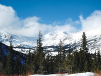
The trail for Woodland and King Lakes goes straight/right; turn left uphill for the Lost Lake Trail. Continue left for Lost Lake. When you reach the Lake, stay left and go around the south side of the lake. Avoid the west side below avalanche chutes that have buried and killed people. The south side of the lake is very safe. Travel around it far enough to see the spectacular views of Chittenden Mountain (10,860 feet) and the South Arapaho (13,397 feet) and Bald Mountain (11,342 feet) massif.
**********
Craving more snowy adventure? Check out all 81 winter hikes included in Snowshoe Routes: Colorado's Front Range.
 CMC Press

Add a comment
Log in to add comments.